


The international hiking path E4 starts in the area of Myloi (400m) and is one of the entrances into the National Park from the town of Litochoro. The path passes through the stunning Enipea Canyon and is well preserved with clear markings and informative signs. After many ascents and descents the path ends in Prionia at the Enipea springs (1100m).
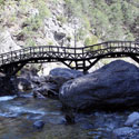
The path starts along Enipea Canyon to the left of the river and half way along the route it crosses the canyon seven times across beautiful wooden bridges thus sometimes having the river on the right and others on the left. In the second half of the route is Agio Spilaio, where Saint Dionysios lived as an ascetic and then after another 20 minutes or so the path reaches Agios Dionysios Monastery which is well worth a visit and is open from April to October. Leaving the monastery behind and continuing along the path after approximately 10 minutes the path begins to descend to the left and after a few minutes arrives at the spectacular Enipea waterfalls.
The route is quite tiring due to the ascents and descents, but the varied geological features, the small lakes with crystal waters and the sheer mountain slopes provide a rare beauty and entirely reward the visitor. The route can also be done in the reverse direction arriving at Prionia or Agios Dionysios Monastery by car and starting out from there.
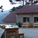
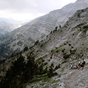
The route from Prionia (1100 m) to Spilios Agapitos Refuge (2100m) is the most frequented hiking path on Mount Olympus and makes up a part of the E4. It is the continuation of the Litochoro – Prionia path. Prionia is the highest point which can be reached by car (it is 18 km from Litochoro) and here there are parking spaces. The source of the Enipea River is also to be found here and a cafe-restaurant operates in Prionia all year long. The majority of the walk is through the forest.
It is worth noting at this point that you should take advantage of the facilities. There are also public toilets, and any water reservoirs, flasks, etc can be filled from the spring. The cars can be left overnight or for long periods.
The path is in very good condition and the combination of thick pine trees with beech and fir trees lend a unique charm to the place. There are several vantage points to see the view, as well as two convenient seating places at roughly 1⁄3 and 2⁄3 distances (please remember not to leave litter at these spots).
At about 2⁄3 you will enter a open section, which zig-zags to the final refuge location. As you enter this section you can see the refuge perched high above on the outcrop. This section can be quite tough as you are already tired from the previous sections, and in summer is open to the sun. So be cautious of dehydration and sunburn (the sun at altitude has stronger UV issues).
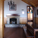
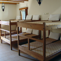
Spilios Agapitos Refuge is located on a natural flat surrounded by impressive age-old Bosnian pine trees.
Duration: 8 hours Altitudinal difference: 1740m Route difficulty: Medium Difficult Length: 17 km


